 SA
SA  KW
KW  IE
IE AU
AU UAE
UAE UK
UK USA
USA  CA
CA DE
DE  QA
QA ZA
ZA  BH
BH NL
NL  MU
MU FR
FR 


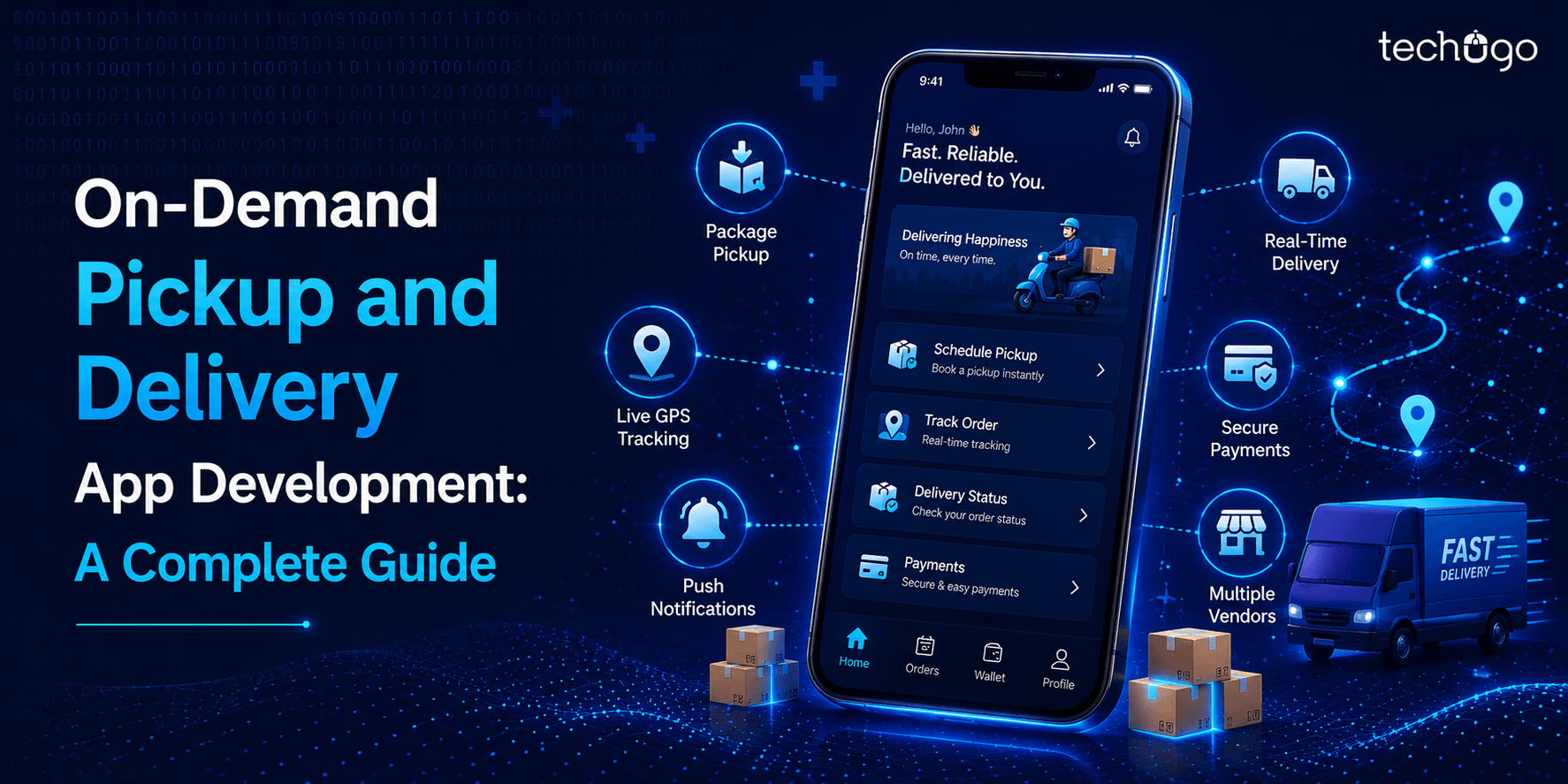
Smartphones have made it easier for people to locate their way. These devices are equipped with a GPS that assists in finding the way for travelers. These indoor navigation apps are a blessing in these modern times when people are always on the go and need to find their way. GPS technology works well outdoors, but indoor navigation apps only work in crowded shops, cafes and restaurants, large shopping malls, and traditional markets.
Indoor navigation and positioning apps are required indoors. They differ from outdoor navigation apps. GPS outdoor navigation apps rely on satellite signals and can lose signal in dense areas, large buildings, or complexes. On the other hand, these indoor mapping software are designed for smaller areas and use augmented reality to display your location by accessing integrated GPS maps. The apps offer the fastest route to your destination by allowing you to access the built-in GPS maps.
Market Statistics For Indoor Positioning Apps
According to statistics, the global Indoor Positioning & Navigation Market was worth $6.92 Billion in 2017. It is expected to rise to $23.6 Billion in 2023. The United States is the largest market for these apps, with a 40% global market share. If you’re looking for an Indoor Navigation app to create, then this is the place for you. Let’s first understand what an Indoor Navigation system is.
What’s an Indoor Positioning System and Navigation App?
Indoor navigation system for shopping malls can locate objects and visitors within buildings. However, GPS indoors is unreliable due to the lack of visual contact with GPS satellites. Thus, the mechanism must therefore use other positioning methods. These include widely accepted consumer standards for WiFi and Bluetooth Low Energy (BLE) and ultra-wideband or passive RFID solutions. The choice of technology and method is the first and most crucial step in the implementation process.
Navigation apps make it easy to find precise locations even in vast spaces. This is the most recent way to find your way. These IPS-enabled services help you quickly find locations at airports and railway stations. It displays the customers’ current locations on maps and directs them to the shortest route so they can quickly get there.
HOW DOES INDOOR NAVIGATION COME OUT?
Indoor navigation apps make it easy to find the right destination quickly and efficiently. To reach their destination, users need only a smartphone or tablet. It is easy to use the Indoor navigation app. It works with ultra-wideband, Bluetooth, and Wi-Fi technology based on the location’s accuracy. The complex algorithm used by the Indoor positioning system to determine the indoor position of the smartphone’s sensors uses internal sensors. This algorithm combines the incoming data from sensors to calculate the precise positioning of your device. If anyone needs an accurate positioning result and a smooth user experience, These are the three main components of an indoor navigation app:
– The foundation of the dynamic positioning platform.
– Signals for the positioning system.
– The smartphone can send signals to beacons.
Indoor navigation app projects combine data from multiple sources to calculate the user’s location. The indoor navigation app must work well. This is why it needs the best functionalities. Not to forget mentioning, drone indoor mapping is another common method of indoor navigation.
– A facility map
– A dedicated app for your mobile phone
– Fingerprinting and BLE Beacons
– Indoor navigation calculation using Back-end Server is an accelerated process.
Top 10 reasons how indoor navigation helps
1. Offers a better shopping experience
It does shopping for the products and stores that interest you faster, easier, and more convenient.
2. Increases sales and customer satisfaction
This reduces the number of people who abandon a shopping center without buying because they are too busy, frustrated, or unable to locate the products and stores they need.
3. Increases mall loyalty
This provides a better shopping experience than kiosks, information desks, and text-for–location services. These positive benefits increase a mall’s brand equity.
4. Increases Rental Revenue
Enhanced shopping experiences bring in more shoppers. Shopping experiences that are more enjoyable for shoppers mean more tenants for retail stores, allowing malls to rent higher.
5. Serves to be the foundation for geo-targeted mobile advertising and analytics
Allows property managers and owners to send mobile ads to shoppers in malls. Also, receive analytics to improve marketing efforts and profitability.
6. Related sales
Shopping is easier when it’s easy to find products and stores. This extra time can be used to purchase ancillary services, such as. You could have lunch or visit additional shops in the mall.
7. Facility management optimized
Understanding traffic flow allows malls to allocate resources more efficiently and optimize lease arrangements.
8. Shopping made easier for visually impaired people
Voice commands can locate products and stores in an indoor shopping center.
9. Technology advances in the future: Ready malls
Combining indoor navigation with augmented and other technologies, this technology elevates shopping to a new level. It also positions malls as innovative.
10. Safety management is improved
If faced with an emergency or fire, this helps shoppers to exit the mall faster.
Who Can Benefit from Artificial Intelligence-Based Indoor Navigation Apps for Everyone?
These systems can be beneficial to many people, including:
Transport Authorities – Government
– Universities
– Hospital owners
– Hotels & Resorts
– Offices & Property Management Companies
– Architects & Builders
– Shopping Mall Owners
– Stadium & Arena Management
– Walking Tour Guides
– National Library Management
– Museum Administration
– Theme Park owners
The Main Features Of An Indoor Navigation App
Because internal navigation applications have complex functionality, providing a complete feature set is necessary. Here’s a list of the most important.
1. Tracking
The navigation app’s positioning feature helps determine the exact location of your device using multiple computing protocols and different positioning patterns.
2. Mapping
The display function in the navigation app allows users to find the shortest route to their destinations. In addition, you can access all data about the complex’s population using the virtualization function in the internal navigation app.
3. Administrative abilities
Administrative Capabilities helps administrative staff maintain beacons effectively and develop advertising strategies for companies.
4. Navigation
Indoor navigation applications have one thing in common: Navigation. This allows customers to find the fastest route to their destination.
5. Monitoring
Monitoring provides statistics about the number of people who enter a complex (motel, malls, malls, hospitals).
6. Notifications
Interior navigation system design features push messages that allow visitors to be directed to their destination by the software. Push notifications are also available to keep you updated online. Find the best tools and services for push notifications.
7. Voice control
The indoor navigation app can be integrated with voice control to make it easier and more user-friendly. For example, voice commands can search specific locations or within large buildings and complexes.
8. Projection of 3D maps
Virtual reality technology is used to integrate 3D mapping. It allows users to view their map with 3D effects.
Used cases for indoor navigation
Indoor navigation can be used in many cases. It assists people in reaching their destinations or locations. It provides valuable information to facility managers, sales coordinators, and premises authorities.
– Health centers
These apps are useful for patients in hospitals. Visitors can quickly find the right department by simply using an app. In addition, the app’s step-by-step instructions will help anyone who is already stressed and can save lives in a crisis.
– Office spaces
With indoor seating available in offices, finding a meeting room, restroom, or department is easy. In addition, employees can designate which conference rooms they would like to use.
– Large stores and shopping centers
Indoor mapping software is used to give shoppers step-by-step directions for particular stores. This allows shoppers to find products in a particular category in large shopping malls.
– Institutions
Institutions are implementing the latest technology. They have decided to make the campus or building more efficient by implementing an internal positioning system. This will allow students to use all the resources institutions offer, like libraries and laboratories, without wasting time.
– Hotels
Indoor apps can make travel much more manageable. This technology can be a lifesaver to those trying to catch a flight in a hurry. It provides step-by-step instructions to help them quickly get to their desired boarding area.
How to Create Indoor Navigation Apps?
We are all aware of indoor navigation apps’ potential benefits to organizations. But how do they work? This guide will walk you through three key ideas, step by step.
1. Pre-contract Stage
Software companies can then focus on customer business and project requirements, find the best solutions and create a technical plan. Product owners, business analysts, project managers, and stakeholders all work together to create a common vision for AR apps while adhering to all project constraints (such as budget, timelines, enterprise environment, technology, and timeframes). It is easier to select a technology stack when technical analysts give an overview of the available development tools.
2. Design Stage
This phase focuses on wireframing, mock-ups, mapping, and other activities.
3. Phase of development
One of the problems with interior navigation is the inability to access the vast amount of satellite map data available for outdoor navigation, thanks to Google Maps or Apple Maps. As a result, custom maps are required for each building’s navigation system and interior areas. As a result, a number of critical aspects can impact the success of a card, including quality and scalability.
The stage also involves creating a Proof of Concept (POC), which allows you to test your concept and its outcome quickly. You can even create a route with a pre-programmed path and add custom features such as speech recognition. To create an AR-based IPS app by an AR/VR development company, you must use either Apple’s AR Kit (or Google’s ARCore) software development kits.
What Technologies are Used for Indoor Navigation Apps?
Many technologies can be used to create an Indoor Positioning System. Here’s a list of some of them:
1. Global Positioning System (GPS)
Although this is the most popular technology in navigation, it does not provide precise positioning or navigation within a building. Although it works well in high-rise buildings like airports, it does not accurately identify details such as floor numbers. This is why manual mapping is the best way to find that information, just like in Google Maps and Apple Maps. GPS is not an option indoors.
2. Visual Positioning System
This is a very advanced technology. For instance, Google uses Street View data to clarify a user’s location in Augmented Reality-based outdoor navigation. It uses the nearby buildings as reference points. ARKit2 also introduced ARWorldMap class, which serves a similar purpose. It is primarily a collection of feature points around a user, such as “the global fingerprint,” that can be identified. However, ARWorldMap is not the only way to determine the precise location of Indoor Positioning.
It is not uncommon for offices to look the same in different locations. For example, corridors and rooms might look identical on different floors. This makes it difficult to determine the location visually. The ARWorldMap can be confused by interior changes, which can cause the ARWorldMap to slow down.
3. Beacon-Based Indoor Navigation
Another popular technology that is used is Beacon-based indoor navigation. This is illustrated by the 2000 Bluetooth Low Energy Bluetooth beacons powered by batteries and installed at Gatwick Airport in the United States. They provide +/-3m accuracy. Apple documentation states that beacons only give approximately. The distance value of beacons is only approximate; therefore, one cannot rely on signal strength when manually calculating this data. When you add in other factors such as cost ($10-20/item), replacement of batteries every one-two years, and range (10-100m), it becomes clear that indoor navigation can only be used under certain conditions. Beacons can still do a good job, but they are less effective than the other indoor positioning technologies on the market. It would be better to use ARKit & ARCore SDKs functionalities to solve the problem of user positioning.
4. Visual Markers
Also known as AR Markers or ARReferenceImages, Visual Marker is an image recognized by Apple’s ARKit, Google ARCore, and other AR SDKs. These markers allow the app to determine where AR content should be placed. For example, the app can tell you where AR content is best placed by placing a visual marker on a wall or a floor.
The visual marker technology can be used for precise positioning with ARCore, up to several millimeters. However, as everyone wants to know the accuracy levels of these apps, the further away the visual marker is from its origin point, the more inaccurate the result. It is possible to place visible markers every 50 meters to address this problem.
5. Wi-Fi hotspots
Wi-Fi hotspots are signal transmitters. They do not track the location of the person. However, your device calculates the person’s area and can drain your battery.
6. Geofencing
Geofencing is done using the device’s built-in compass and the location’s geomagnetic maps. The magnetic field must remain stable during this time.
WHAT IS THE COST TO DEVELOP AN INDOOR NAVIGATION AND APP DEVELOPMENT APP?
This question is difficult to answer as it is hard to resolve definitively. Each app’s cost depends on the requirements. The cost of app development depends on many factors such as the app’s functionality, features, design, platform, location, and size. Every app owner has a different requirement. Therefore, there needs to be an online calculator to calculate the exact cost of indoor navigation system for shopping malls.
Let’s learn in-depth about the different factors in developing navigation apps.
1. The platform you choose to launch the app
This is the main factor determining indoor navigation apps’ cost. If your budget is limited, it’s better to choose one platform: iOS or Android native apps. It is best to launch the first version after you have started.
2. UX/UI Design
It is important to be certain about the design. However, it makes a good impression on the app. The app should be attractive and well-designed. You can increase your customer base and save money by using best design practices. You might pay a little more to hire the best app development company for UI/UX design.
3. App size and complexity
The price of hiring a top-rated indoor navigation app development company will depend on the functionality and complexity of your application. The more complicated the application, the more expensive it will be to develop. Hire the best professionals if you create an indoor navigation app similar to Google indoor.
4. Developer team
The development cost for the best indoor navigation system for shopping malls dramatically depends on the development team you hire. You will need the best app developer to help you with your project.
5. Location selection
It is an important part of an indoor navigation app. However, the cost will vary depending on the chosen location. In addition, app development costs vary depending on where you are located.
FAQs
1. How do you create an indoor navigation app?
For a step-by-step guide to uploading and creating maps around the world, click here
– Set your goals
– Decide how to create your indoor maps
– Claim Your Building
– To draw your indoor map, use your floor plan
– Identify points of interest (POIs)
– Integrate other data source
2. What is the development time for a navigation app?
A typical navigation app will require 150-200 hours of user interface development. Front-end development takes 500-600 hours.
3. What is Indoor Navigation?
A client application is a common name for internal auto-positioning navigation software. Because it determines the location directly from the user’s smartphone, an app is required.
Wrapping up
We have now covered all aspects of indoor navigation app design. There are many advantages. What is the cost of developing mobile apps? Their uses?
Contact an indoor navigation app developer company if you are interested in creating such apps. Techugo a leading mobile app development company can handle any niche or domain, and all with the most advanced technologies.
Contact us for more information about the cost of indoor navigation app development. We are happy to assist you.
Get in touch
We'd love to hear from you.